UNIT THREE

Home | Table of Contents | Flashcard List | Lesson 1 | Lesson 2 | Lesson 3 | Lesson 4 | Lesson 5 | Lesson 6 | Lesson 7 | Lesson 8 | Lesson 9 | Lesson 10 | Activity 12 | Activity 13 | Activity 14 | Activity 15 | Activity 16 | Activity 17 | Activity 18 | Activity 19 | Activity 20 | Activity 21 | Activity 22 | Activity 23 | Activity 24 | Activity 25 | Activity 26 | Activity 27 | Activity 28 | Activity 29 | Activity 30 | Activity 31 | Activity 32 | Activity 33 | Activity 34 | Activity 35 | Activity 36 | Activity 37 | Activity 38

Lesson 4

Learning How to Draw Latin America

LEFT SIDE
PAGE 14

1
WARM-UP
 
What does the term "Latin America" mean?


3
PRACTICE
 
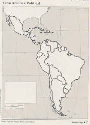
Without the aid of a map,
draw North and South America.
 
Label any water and land features you know.
 
Where did the line of longitude that runs through the peninsula of Florida run through South America?
 
How many main islands are there in the Caribbean?

RIGHT SIDE
PAGE 15


2
NOTES:
What Is Latin America?


4
OBJECTIVE:
  • Visually represent the region of Latin America.

5
Draw Free-hand the Map of Latin America.
  • Remember to line up the peninsula of Florida with the WEST coast of South America.
  • Label the following features:
    • North America
    • Middle America
    • South America
    • Pacific Ocean
    • Atlantic Ocean
    • Caribbean Sea
    • Gulf of Mexico

CLICK

for a LARGER version.